Serving the residents of Hull's Allerton Hill neighborhood

POINT ALLERTON ASSOCIATION
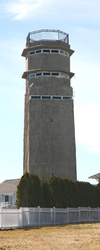
THE TOWER
It rises high above Allerton Hill, visible from anywhere in the town of Hull. For as long as we have lived on the hill, the tower has been there... a constant companion, standing watch like some giant, silent sentinel. Here's the story of what it is and how it got there.
Point Allerton forms the northeast elbow of Nantasket Peninsula in Hull, MA and juts into the Atlantic Ocean at the southern edge of the approaches to Boston Harbor. Since 1907 the Point has housed a succession of fire control buldings, towers, and radars that have played a key role in guarding the harbor and controlling its coast defense artillery.
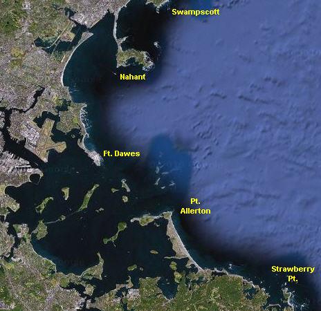
The general harbor map at left shows that Ft. Dawes on the north and Pt. Allerton on the south enclose the harbor approaches like two large jaws. Indeed, during WW2, Ft. Dawes was the site of the most important position in controllling harbor traffic, the Harbor Entrance Control Point (HECP), while one of the bunkers atop Pt. Allerton held the command post for the entire South Group command. (The North Group CP was located in the fire control tower at Ft. Ruckman in Nahant.)
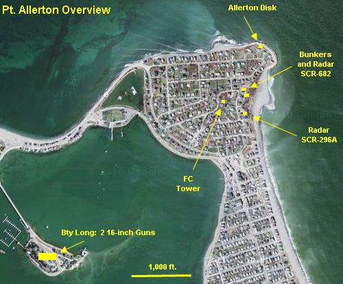
The Pt. Allerton Overvew map pinpoints most of the Point Allerton facilites. The 7-story fire control tower in the center of the Point, by virtue of its base elevation (124 feet), had its top observation level at 179 feet above sea level, making this the tallest observation point (except for the anti-aircraft crow's nest peeking through that tower's roof) in the Boston harbor defenses. This is the only building that still survives.
Of the facilites that have been destroyed, two are the small bunkers on the eastern edge of the Point that were built to resemble a garage and a bungalow but which controlled some of the harbor's largest guns. The antenna for a harbor entry search radar occupied a dome atop one of these buildings, and a fire control radar just down Bluff Rd. to the south had the axis of its antenna 157 feet above the sea. A little over a mile further south down the peninsula was Strawberry Hill. which featured another fire control radar and a cluster of fire control buildings. Finally, a geodetic disk at the tip of the Point helped to locate the precise positions of these assets.
The Overview map also indicates the position (roughly a mile to the southwest) of the first 16-inch gun battery in Boston's defenses, Battery Long in Hull Bay, on what today is called Spinnaker Island. (The island was renamed when it was purchased by a developer and filled with condominiums, one of which uses one of the huge former gun platforms as a parking area.) Battery Command for these guns was situated in the same Pt. Allerton bunker as the South Group command.
The general harbor map at left shows that Ft. Dawes on the north and Pt. Allerton on the south enclose the harbor approaches like two large jaws. Indeed, during WW2, Ft. Dawes was the site of the most important position in controllling harbor traffic, the Harbor Entrance Control Point (HECP), while one of the bunkers atop Pt. Allerton held the command post for the entire South Group command. (The North Group CP was located in the fire control tower at Ft. Ruckman in Nahant.)
The Pt. Allerton Overvew map pinpoints most of the Point Allerton facilites. The 7-story fire control tower in the center of the Point, by virtue of its base elevation (124 feet), had its top observation level at 179 feet above sea level, making this the tallest observation point (except for the anti-aircraft crow's nest peeking through that tower's roof) in the Boston harbor defenses. This is the only building that still survives.
Of the facilites that have been destroyed, two are the small bunkers on the eastern edge of the Point that were built to resemble a garage and a bungalow but which controlled some of the harbor's largest guns. The antenna for a harbor entry search radar occupied a dome atop one of these buildings, and a fire control radar just down Bluff Rd. to the south had the axis of its antenna 157 feet above the sea. A little over a mile further south down the peninsula was Strawberry Hill. which featured another fire control radar and a cluster of fire control buildings. Finally, a geodetic disk at the tip of the Point helped to locate the precise positions of these assets.
The Overview map also indicates the position (roughly a mile to the southwest) of the first 16-inch gun battery in Boston's defenses, Battery Long in Hull Bay, on what today is called Spinnaker Island. (The island was renamed when it was purchased by a developer and filled with condominiums, one of which uses one of the huge former gun platforms as a parking area.) Battery Command for these guns was situated in the same Pt. Allerton bunker as the South Group command.
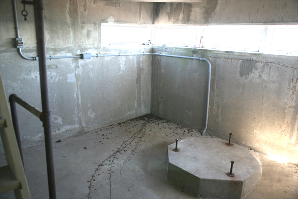
6th Floor Observation Position: In this view, wooden replacement windows (obscured by the sun) line the observation slit on the northern and eastern (seaward) sides of the 6th story. The octagonal concrete pad with its three mounting bolts formerly held the Depression Position Finder (DPF) and the center of this pad, projected to the roof, is marked by a geodectic disk to locate it precisely for fire control. It is rare to find these pads surviving.
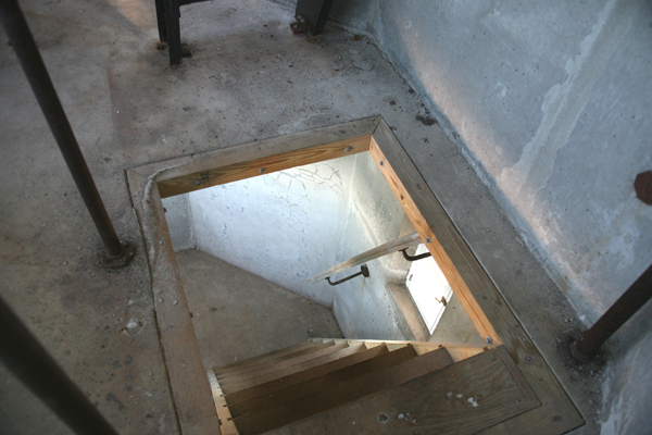
Gangway Down to the 6th Floor: This gangway, of pressure-treated wood, is a modern replacement for the wartime verical ladder. The cast iron pipe railings on the 7th story are original.
Artillery Fire Control Tower
BACK TO HISTORY

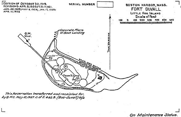
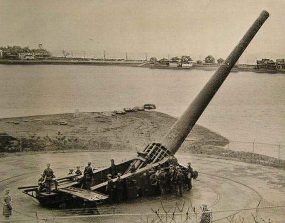
Fort Duvall on Hog Island: Coast watchers manning the Allerton Hilll tower directed fire from a pair of 16 inch guns mounted at Hog Island (now Spinnaker Island) in Hull Bay. Hidden behind Allerton Hill and the Hull peninsula (background), Fort Duvall could not be observed from the Atlantic Ocean.
1938 Map of Fort Duvall on Hog Island (now Spinnaker Island) with Battery Long and its 16 inch guns indicated. The guns were scrapped in 1948. During World War 2, there was no bridge connecting the island to the Hull peninsula.